The Western Hills Viaduct
The Western Hills Viaduct isn’t just a symbol of the Queen City, it’s a reflection of the nation at large. Nothing says “America” quite like an ornately designed, historic piece of infrastructure that’s been left to rot. One that carries a mix of threadbare public transit, obnoxiously large pickup trucks, and cars that are hopefully hanging on just a bit longer so that their owners can try and get by. You can witness this all up close, but only if you’re daring enough—and physically able—to walk alongside four lanes of speeding traffic.

The Western Hills Viaduct as seen from Fairview Park.
This isn’t some sort of startling revelation, though. The need to fix this bridge has been a topic of conversation throughout greater Cincinnati for some time. However, in keeping with the aforementioned patriotic tradition, proposed solutions have long been political punching bags. And while there now seems to be real hope on the horizon, the viaduct continues to crumble—dropping chunks of concrete onto windshields and tossing hubcaps into the rail yards below. All while citizens waits for a replacement.

One of the viaduct’s iconic arches spanning Spring Grove Ave.
Back when I originally published Queen City Discovery and urban exploration was the dominant subject in my work, I had a list of places I wanted to go explore and document. These potential topics ranged from sights across the country to those within my hometown. Yet, after all those years, there was one in Cincinnati that I just never got around to. I’d been passing by the “stairs closed” sign for years, occasionally pausing to glance up at the abandoned concrete steps which rose to meet the iconic, yet aging superstructure of the Western Hills Viaduct. Over a decade later, I finally got around to climbing them—taking in the view of the city from a shaking platform as interstate traffic rushed below.
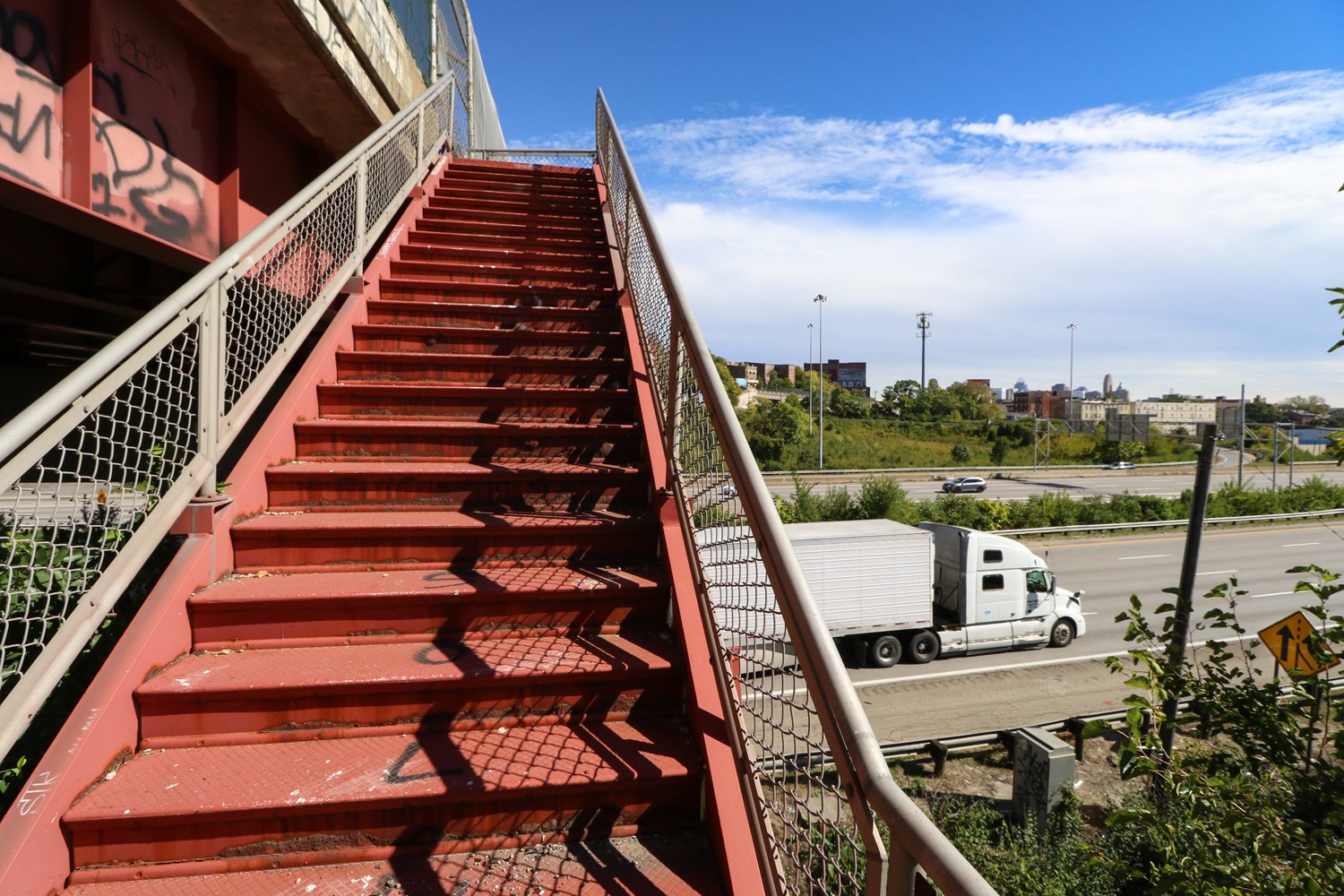
Derelict viaduct pedestrian stairs overlooking Interstate 75 with the city skyline in the far distance.
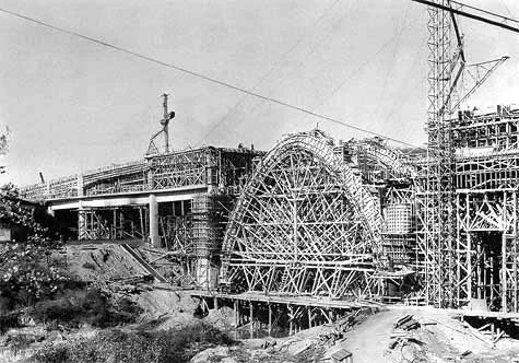
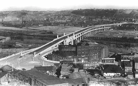
The viaduct was built between 1930 and 1932 as part of the city of Cincinnati’s Union Terminal project. Spanning 3,500 ft, the structure crosses over the Mill Creek, CSX’s Queensgate rail yard, and local streets. With two decks for automobile traffic and connections to nearby Interstate 75, the bridge is a vital artery between the city’s west side and urban core. Visually, it’s denoted by distinct arches, Art Deco details, and concrete construction—an atypical example of American infrastructure of the era. One that combined function with striking design intended to evoke civic pride.
Historic photographs of the viaduct under construction as seen in “Cincinnati Union Terminal: Design and Construction
of an Art Deco Masterpiece” and featured on Cincinnati-Transit.net:
The viaduct predated the modern standardization of roads and interstate highways. Once historic streetcars disappeared from Cincinnati streets and the personal automobile grew in both individual numbers and physical size, the viaduct came to be seen as an intimidating route of travel for many motorists.

Driving along the viaduct’s lower level.
The lower deck, a thoroughfare where temporary nets attempt to catch falling concrete, is quite narrow. A series of lanes where traffic will often come to an abrupt stop as cars attempt to navigate the exit ramps.

Nets lining the area above the viaduct’s lower deck are intended to catch bits of concrete and debris that occasionally fall from the aging structure.
Meanwhile on the upper deck, the speed limit may read 35 mph, but drivers tend to treat the bridge as a speedway. There are no emergency lanes and pedestrian access is limited to only one side with no protective barrier between the sidewalk and automobile traffic. For citizens with mobility issues, the viaduct is inaccessible as the western end requires any passersby to negotiate a set of stairs.

The viaduct’s upper deck and its sole means of pedestrian access: the southern sidewalk.

Stairs on the viaduct’s western end connect the bridge’s only sidewalk with the neighborhood of South Fairmount.
The other set of steps mentioned at the beginning of this article, the ones I’d long had on my “list,” are a former pedestrian connection that has been officially cut off for many years. Beginning on Spring Grove Ave. beneath the viaduct’s eastern archway, this pathway once featured a “stairs closed” sign and simple steel barrier. At the top, where the steps split into two directions to serve both sides of the viaduct, chain link fencing was used to disconnect the stairs from the viaduct’s upper deck sidewalks (although, the northern sidewalk seems to have been completely removed some time ago). All of these obstacles have been disregarded by those seeking an easier walking route and those seeking shelter. The steel barrier on Spring Grove Ave. was pried open at some point and the upper chain link fence has also been pulled back in several places. Discarded clothing, food packages, and the occasional syringe line the stairway.

Spring Grove steps with their barrier pried open.

View of Spring Grove Ave. and the viaduct’s lower deck from the derelict stairs.

Multiple holes have worn straight through the concrete on the aging stairs.

Where the stairs split into two to serve both sides of the viaduct’s upper deck. The northern sidewalk was removed some time ago.

Fencing installed with the intention of cutting off stairway access. For several years, it has been pried back.

Where the Spring Grove Ave. stairway meets the upper deck sidewalk.

The viaduct’s northern side and former stairway connection. The sidewalk here was removed long ago.
Replacing the Western Hills Viaduct has been a stated goal for politicians across the political spectrums of Cincinnati and Hamilton County for decades. After the passage of a countywide 2020 tax levy (which aims to improve public transportation in addition to providing funds for a viaduct replacement), a 2022 federal grant, and other funding sources were combined—a firm plan for the viaduct’s replacement finally emerged. Per the City of Cincinnati, construction is slated to being in 2025 with an estimated completion date of 2030.
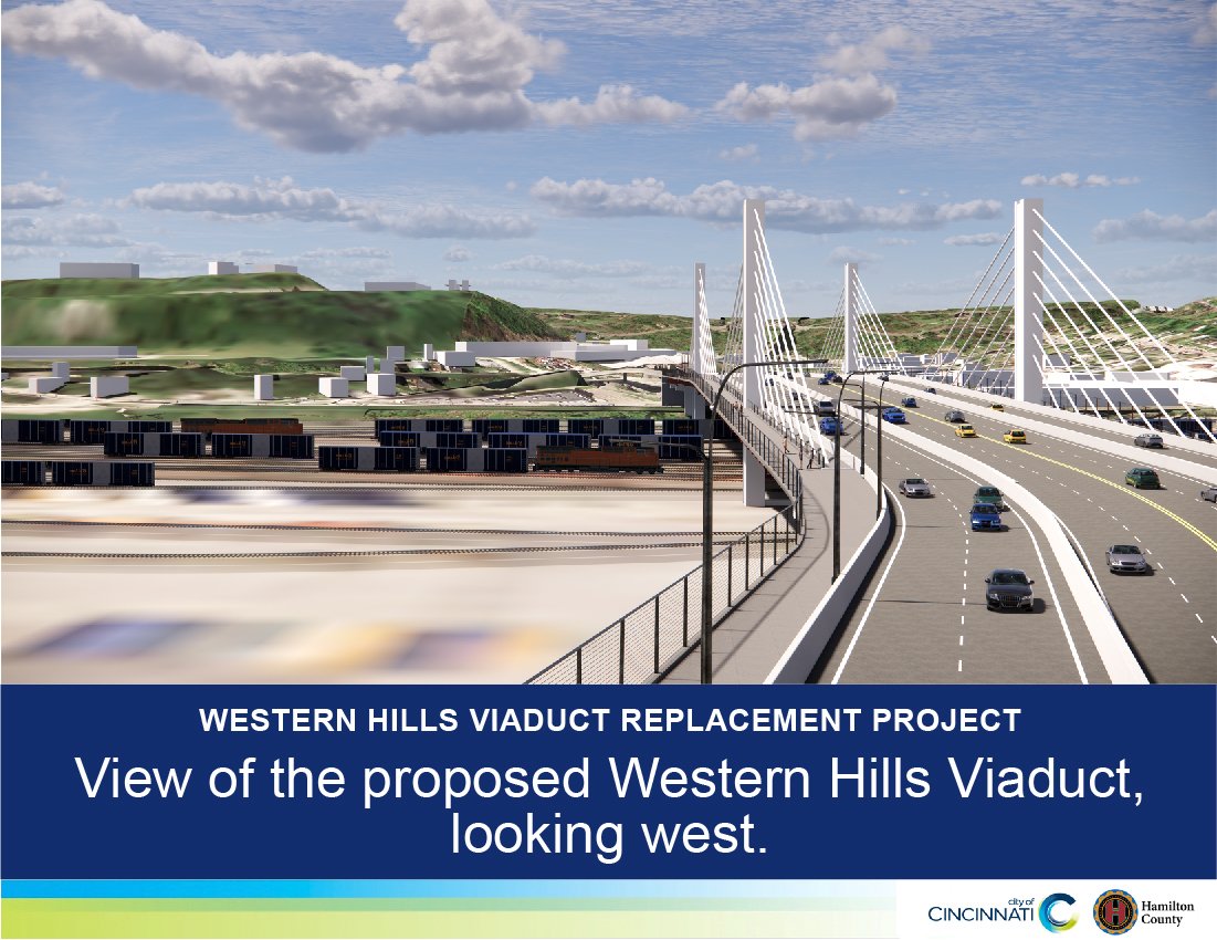
Rendering of the new viaduct via The City of Cincinnnati.
The new Western Hills Viaduct is expected to feature one deck, two sets of cable-stayed towers, a total of eight traffic lanes, and a multi-use (pedestrian and bicycle) path on one side with a sidewalk on the other. Exclusive transit only lanes have been suggested, but as of this writing, no firm commitment has been made for future bus rapid transit or light rail/modern streetcar accommodations.
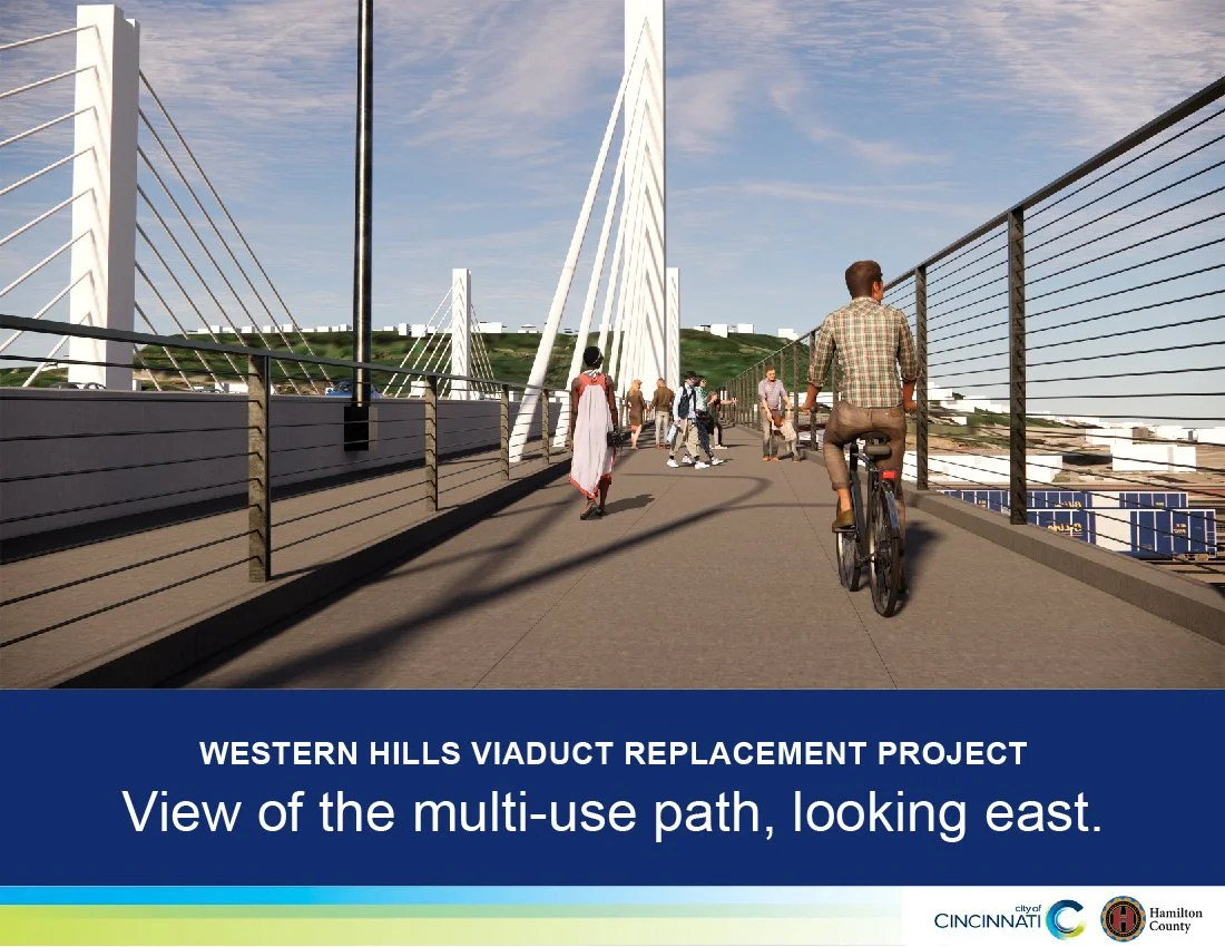
Rendering of the new viaduct’s multi-use path via The City of Cincinnnati.
Although the existing viaduct will still be around for several more years, I wanted to go out and document it as is, before its surroundings are changed and it’s ultimately demolished. While the replacement will certainly be a welcomed improvement by the citizens of greater Cincinnati, the original viaduct is very much an iconic piece of the Queen City’s urban fabric.
View from Buck St.

View from Buck St.

View from Buck St.

View from Buck St.

View from Spring Grove Ave.

View from Spring Grove Ave. of one of the viaduct’s interstate connection ramps.

The viaduct’s lower deck.

Decorative detail on the upper deck.

The city’s skyline as seen from the upper deck. The Brighton neighborhood is in the foreground.

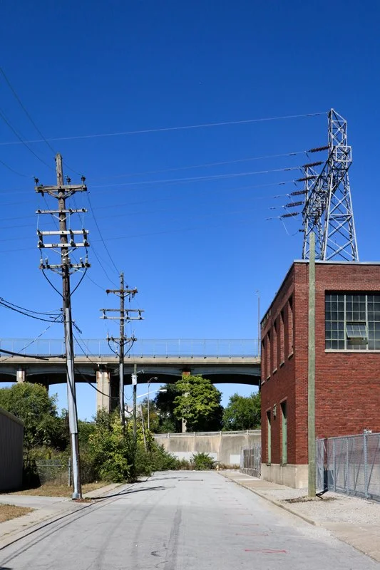
CSX control tower as seen from the viaduct, standing above the company’s Queensgate rail yard.

CSX’s Queensgate rail yard. This are also serves the city’s lone Amtrak passenger train: the thrice-weekly Cardinal.

Queensgate yard details.

The Queensgate yard and city skyline.

Viaduct signage.
Aerial photographs made and provided courtesy of Travis Estell:
(tap each aerial photograph to open in a new window)


The Mill Creek as seen from the viaduct’s upper level.

Upper deck signage.

South Fairmount’s Lunkenheimer Building as seen from the viaduct. This building was previously featured in a 2014 story.

The neighborhood of South Fairmount as seen from the viaduct.

Entrance ramp to the viaduct’s lower level.

Stairway connection between the viaduct’s only remaining pedestrian connection.

The viaduct extending over the surrounding landscape.

Viaduct details.

Viaduct signage on the western end.

Improvised repairs on the western side.

A long closed access tunnel to the viaduct on the western side. While this historical photograph from Cincinnati-Transit.net shows streetcar tracks on the viaduct’s lower level, I’m not sure if the above tunnel was once exclusively for streetcar access. There are a series of roads/tunnels at the viaduct’s western terminus that seem as if they were once for rail transit connections.
EDIT: Thanks to commenter Nicholas J. Recitin below, it turns out that this tunnel connection to the viaduct’s western end was in fact once for the exclusive use of the Cincinnati Transit Company’s streetcars.

The former streetcar access tunnel as seen from State Ave.

Western terminus in the South Fairmount neighborhood.

View from South Fairmount.

View from South Fairmount.

Decorative details. Similar design choices can be seen all across the city in infrastructure of this era, including the never-used subway tunnels.

View from South Fairmount.

Older signage at the viaduct’s western end. Not the reflective surface on the letters and interstate shield. This style has been out of us for many years now.

Western exit portal from the lower deck to Harrison Ave.

Detail of the eastern end showcasing exposed rebar.

Eastern archway over Spring Grove Ave.

View of the upper deck from the lower deck showcasing the viaduct’s extensive wear.

View of the upper deck from the lower deck showcasing the viaduct’s extensive wear.

Driving westbound on the viaduct’s lower deck.
NOTE: All photographs seen here are ©2022 Ronny Salerno unless otherwise noted. Aerial photography provided courtesy of Travis Estell. Historic images via Cincinnati-Transit.net.
Related Stories:
The Waldvogel Viaduct in 2012: another aging, Cincinnati bridge which has now been demolished and replaced.
Death of the Dennison: long-form photographic documentation of an historic Cincinnati building.
Stories of the Cincinnati Subway: the city’s famous abandoned transit project.
Union Terminal: Cincinnati’s iconic train station constructed around the same time as the Western Hills Viaduct.
The Catacombs of Cleveland: another historic midwestern bridge with its own lower deck history.
Since 2007, the content of this website (and its former life as Queen City Discovery) has been a huge labor of love.
If you’ve enjoyed stories like The Ghost Ship, abandoned amusement parks, the Cincinnati Subway, Fading Ads, or others over the years—might you consider showing some support for future projects?